Day 354: Back to Canada

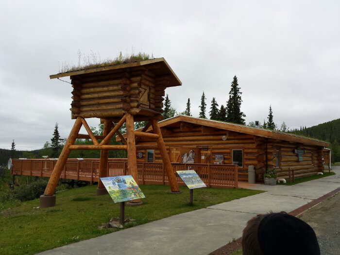
This morning, we stopped at the visitor center at Tetlin National Wildlife Refuge. The visitor center has on display a cache structure. It would be filled with food, tools, and other things need to survive the winter so that if the main cabin burned down, the trapper would still have what he needed to survive through the winter:
image

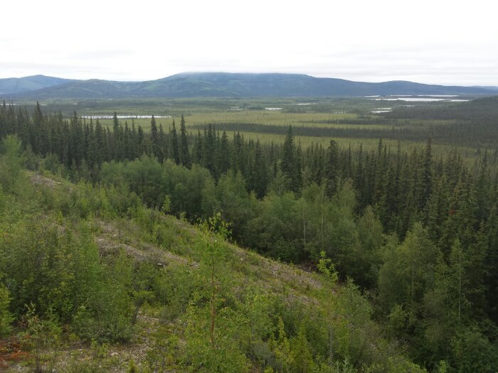
The view from the visitor center on to the refuge:
image

Driving East, we crossed into Canada without incident and continued driving until we reached Haines Junction. On the way, we passed a grizzly grazing on the side of the road as well as another pair of bears running along the rosd a while later. We also wound our way around the shore of Kluane Lake, which had emerald green water. Quite the view of the St. Elias mountains from Haines Junction:

image

Unfortunately, there was a good bit of road construction and some of the road was dirt, so our truck is dirty again:

image

Tonight, we are overnighting in a grocery store parking lot in Whitehorse, Yukon Territory. See the trip map for driving details.

Day 352: Coming Clean

This morning we went to the free car wash in Tok at the Tesoro station and spent an hour or so scrubbing off the 1000 miles of Dalton Highway dust. It’s nice to have our white truck back:

image

We drove just a bit South of town to the Tetlin National Wildlife Preserve headquarters:

image

The kids completed their Junior Ranger workbooks:

image

We then drove about 60 miles East to Tetlin NWR’s free campground on Deadman Lake. Thankfully, the only spot that would fit our monster RV was available:

image

While Trish made Shabbos dinner, I replaced the RV’s two manual thermostats with digital ones:

image

image

Good Shabbos from Deadman Lake, near the Alaska/Canada border! See the trip map for today’s drive.

Day 351: National Park Bigger than Switzerland

This morning we drove to the end of the Glenn Highway and about 6 miles South on the Richardson Highway to the visitor center for Wrangell-St. Elias National Park.  This park is the largest in the park system, is larger than Switzerland, and contains 7 of the 10 tallest mountains in North America.

The kids worked on their Junior Ranger workbooks.  Here I think there looking at what I hope is simulated bear and moose scat:

Day351_01

Day351_02

The visitor center had pelts and skulls of area animals on display:

Day351_03

Day351_05

The kids received their badges:

Day351_04

Outside there’s a fish wheel on display, a kind of water wheel that scoops up salmon as they swim upstream to spawn:

Day351_06

It was too cloudy to see the Wrangell Mountains from the visitor center.  We did a brief hike out to an overlook of the Copper River:

Day351_07

Day351_08

We only saw one colony of these mushrooms, each one the size of a ping pong ball:

Day351_09

The mosquitoes in the forest were plentiful and aggressive.  We walked very fast to stop them from landing on us.  Despite this, M walked behind Trish and swatted them when they landed on her.  These are just the ones that stuck to her shirt.  Yummy!

Day351_10

After leaving the visitor center, we drove North to the Tok Cutoff to overnight at the Chevron in Tok as we did the first time we came through three weeks ago.  See the trip map for driving details.

Day 350: Flying to the Knik River

This morning we got up early so I could fly before thermals made the air too bumpy.  We got out to the field close to three hours after sunrise, since the sun comes up a bit before 5AM here.  I warmed up the motor, leaning back into its thrust:

Day350_01

The run out and launch went flawlessly:

Day350_02-2

I gained altitude as I flew out towards the river and our RV:

Day350_03

Day350_04

Ground control was standing by:

Day350_05

M watches me come in for a landing:

Day350_06

Unfortunately, I had a bit of windsock dyslexia and landed downwind instead of upwind.  Thankfully, the wind wasn’t that strong, but it still made for a landing that was too fast to run out, so I kind of skidded in to a stop.  Thankfully, neither pilot nor gear were harmed:

Day350_07-2

It was cold enough that I got to try out my swanky flight suit:

Day350_08

Day350_09

It was great to get back in the air!  Here’s a screen capture from the action camera shortly after takeoff:

Day350_10

After the flight, we continued North and rejoined the Glenn Highway.  At mile 101, we pulled off to view the Matanuska Glacier:

Day350_11

We hiked an interpretive trail at the overlook:

Day350_12

Day350_13

Day350_14

Continuing North, we passed more mountain vistas:

Day350_15

Day350_16

Tonight we’re overnighting at a pullout on the Glenn Highway about 50 miles West of Glenallen.  See the trip map for details.

Day 349: North to the Knik River

This morning, B and I went for a short ride on the Girdwood to Bird bike path, which largely parallels the Seward Highway along the Turnagain Arm.  This location has tidal swings of over 30 feet, the second highest variation in the world.  While on the ride the tide was mostly out, so most of the Turnagain Arm here was just a mud flat:

Day349_02

As usual, we did a some of our homeschooling in the car:

Day349_01

We drove North on the Glenn Highway, then the Old Glenn Highway to the town of Butte.  The paragliders I met in Girdwood yesterday gave me contact information for a PPG pilot in Anchorage who told me about a farm field in Butte where I could take off and land.  We left the RV in a dispersed camping area on the Knik River, then drove the three miles North to the launch site:

Day349_03

Kicking up dust to check the wind:

Day349_04

Since I hadn’t done forward launches in almost a month, I practiced this a bit:

Day349_05

Day349_06

Day349_07

B is ready for take off:

Day349_08

By the time I was ready to put on the motor, it was close to 10PM, so we called it a night.  I’ll come back and fly tomorrow.  You can’t beat the views from this field:

Day349_09-2

See the trip map for today’s drive.